- java.lang.Object
-
- com.supermap.analyst.spatialanalyst.TerrainBuilderParameter
-
public class TerrainBuilderParameter
extends Object
地形构建参数类。该类为地形构建(buildTerrain方法)提供必要的参数信息,包括用于构建地形的点、线数据集,及相应的高程字段、裁剪数据集、擦除数据集、采样距离、结果 DEM 栅格的像素格式、单元格大小等等。
-
-
构造器概要
构造器 构造器和说明 TerrainBuilderParameter()构造一个新的 TerrainBuilderParameter 对象。TerrainBuilderParameter(TerrainBuilderParameter parameter)根据给定的 TerrainBuilderParameter 对象构造一个与其完全相同的新对象。
-
方法概要
所有方法 实例方法 具体方法 限定符和类型 方法和说明 doublegetCellSize()返回结果数据集的栅格单元的大小。DatasetVectorgetClipDataset()返回用于裁剪的数据集。EncodeTypegetEncodeType()返回编码方式。DatasetVectorgetEraseDataset()返回用于擦除的数据集。TerrainInterpolateTypegetInterpolateType()返回地形插值类型。StringgetLakeAltitudeFiled()返回湖泊面数据集的高程字段。DatasetVectorgetLakeDataset()返回湖泊面数据集。String[]getLineAltitudeFileds()返回线数据集的高程字段数组。DatasetVector[]getLineDatasets()返回线数据集数组。PixelFormatgetPixelFormat()返回结果数据集的像素格式。String[]getPointAltitudeFileds()返回点数据集的高程字段数组。DatasetVector[]getPointDatasets()返回点数据集数组。doublegetResampleLen()返回采样距离。TerrainStatisticTypegetStatisticType()返回源数据集中重复点的处理方式。doublegetZFactor()返回高程缩放系数。booleanisProcessFlatArea()返回是否处理平坦区域。voidsetCellSize(double cellSize)设置结果数据集的栅格单元的大小。voidsetClipDataset(DatasetVector clipDataset)设置用于裁剪的数据集。voidsetEncodeType(EncodeType encodeType)设置编码方式。voidsetEraseDataset(DatasetVector eraseDataset)设置用于擦除的数据集。voidsetInterpolateType(TerrainInterpolateType interpolateType)设置地形插值类型。voidsetLakeAltitudeFiled(String lakeAltitudeFiled)设置湖面数据集的高程字段。voidsetLakeDataset(DatasetVector lakeDataset)设置湖泊面数据集。voidsetLineAltitudeFileds(String[] lineAltitudeFileds)设置线数据集的高程字段数组。voidsetLineDatasets(DatasetVector[] lineDatasets)设置线数据集数组。voidsetPixelFormat(PixelFormat pixelFormat)设置结果数据集的像素格式。voidsetPointAltitudeFileds(String[] pointAltitudeFileds)设置点数据集的高程字段数组。voidsetPointDatasets(DatasetVector[] pointDatasets)设置点数据集数组。voidsetProcessFlatArea(boolean processFlatArea)设置是否处理平坦区域。voidsetResampleLen(double resampleLen)设置采样距离。voidsetStatisticType(TerrainStatisticType statisticType)设置源数据集中重复点的处理方式。voidsetZFactor(double factor)设置高程缩放系数。
-
-
-
构造器详细资料
-
TerrainBuilderParameter
public TerrainBuilderParameter()
构造一个新的 TerrainBuilderParameter 对象。
-
TerrainBuilderParameter
public TerrainBuilderParameter(TerrainBuilderParameter parameter)
根据给定的 TerrainBuilderParameter 对象构造一个与其完全相同的新对象。- 参数:
parameter- 给定的 TerrainBuilderParameter 对象。
-
-
方法详细资料
-
getLineDatasets
public DatasetVector[] getLineDatasets()
返回线数据集数组。- 返回:
- 线数据集数组。
-
setLineDatasets
public void setLineDatasets(DatasetVector[] lineDatasets)
设置线数据集数组。- 参数:
lineDatasets- 线数据集数组。
-
getPointDatasets
public DatasetVector[] getPointDatasets()
返回点数据集数组。- 返回:
- 点数据集数组。
-
setPointDatasets
public void setPointDatasets(DatasetVector[] pointDatasets)
设置点数据集数组。- 参数:
pointDatasets- 点数据集数组。
-
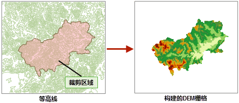
getClipDataset
public DatasetVector getClipDataset()
返回用于裁剪的数据集。- 返回:
- 用于裁剪的数据集。
构建地形时,仅位于裁剪区域内的 DEM 结果被保留,区域外的部分被赋予无值。
-
setClipDataset
public void setClipDataset(DatasetVector clipDataset)
设置用于裁剪的数据集。构建地形时,仅位于裁剪区域内的 DEM 结果被保留,区域外的部分被赋予无值。

- 参数:
clipDataset- 用于裁剪的数据集。
-
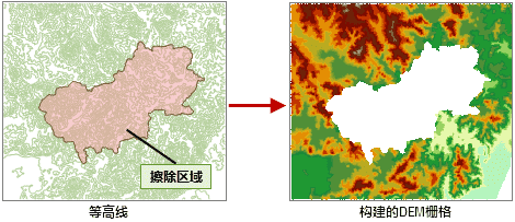
getEraseDataset
public DatasetVector getEraseDataset()
返回用于擦除的数据集。- 返回:
- 用于擦除的数据集。 构建地形时,位于擦除区域内的结果 DEM 栅格值为无值。
-
setEraseDataset
public void setEraseDataset(DatasetVector eraseDataset)
设置用于擦除的数据集。- 参数:
eraseDataset- 用于擦除的数据集。构建地形时,位于擦除区域内的结果 DEM 栅格值为无值。仅在
setInterpolateType设置为TIN时有效。
-
getLakeDataset
public DatasetVector getLakeDataset()
返回湖泊面数据集。- 返回:
- 湖泊面数据集。
结果数据集中湖泊面数据集区域范围内的高程值小于周边相邻的高程值。
-
setLakeDataset
public void setLakeDataset(DatasetVector lakeDataset)
设置湖泊面数据集。- 参数:
lakeDataset- 湖泊面数据集。结果数据集中湖泊面数据集区域范围内的高程值小于周边相邻的高程值。
-
getLineAltitudeFileds
public String[] getLineAltitudeFileds()
返回线数据集的高程字段数组。- 返回:
- 线数据集的高程字段数组。
-
setLineAltitudeFileds
public void setLineAltitudeFileds(String[] lineAltitudeFileds)
设置线数据集的高程字段数组。- 参数:
lineAltitudeFileds- 线数据集的高程字段数组。
-
getPointAltitudeFileds
public String[] getPointAltitudeFileds()
返回点数据集的高程字段数组。- 返回:
- 点数据集的高程字段数组。
-
setPointAltitudeFileds
public void setPointAltitudeFileds(String[] pointAltitudeFileds)
设置点数据集的高程字段数组。- 参数:
pointAltitudeFileds- 点数据集的高程字段数组。
-
getLakeAltitudeFiled
public String getLakeAltitudeFiled()
返回湖泊面数据集的高程字段。- 返回:
- 湖泊面数据集的高程字段。
-
setLakeAltitudeFiled
public void setLakeAltitudeFiled(String lakeAltitudeFiled)
设置湖面数据集的高程字段。- 参数:
lakeAltitudeFiled- 湖面数据集的高程字段。
-
getStatisticType
public TerrainStatisticType getStatisticType()
返回源数据集中重复点的处理方式。由于各种原因,可能导致用构建地形的源数据有重复点(或节点)情况出现。如果重复点的高程值不同,就需要对重复点进行处理。可以选择使用第一个点的高程值,也可以使用所有重复点的高程值的统计值,如平均值、最大值等。
- 返回:
- 重复点的处理方式。
- 默认值:
- 默认值为
TerrainStatisticType.UNIQUE。
-
setStatisticType
public void setStatisticType(TerrainStatisticType statisticType)
设置源数据集中重复点的处理方式。由于各种原因,可能导致用构建地形的源数据有重复点(或节点)情况出现。如果重复点的高程值不同,就需要对重复点进行处理。可以选择使用第一个点的高程值,也可以使用所有重复点的高程值的统计值,如平均值、最大值等。
- 参数:
statisticType- 重复点的处理方式。
-
getInterpolateType
public TerrainInterpolateType getInterpolateType()
返回地形插值类型。- 返回:
- 地形插值类型。
- 默认值:
- 默认值为 IDW。
-
setInterpolateType
public void setInterpolateType(TerrainInterpolateType interpolateType)
设置地形插值类型。- 参数:
interpolateType- 地形插值类型。
-
getCellSize
public double getCellSize()
返回结果数据集的栅格单元的大小。- 返回:
- 结果数据集的栅格单元的大小。
- 默认值:
- 默认值为 L/500,其中 L 是指源数据集的区域范围对应的矩形的对角线长度。
-
setCellSize
public void setCellSize(double cellSize)
设置结果数据集的栅格单元的大小。如果指定为 0 或负数,则系统会使用 L/500(L 是指源数据集的区域范围对应的矩形的对角线长度)作为单元格大小。
- 参数:
cellSize- 结果数据集的栅格单元的大小。
-
getZFactor
public double getZFactor()
返回高程缩放系数。- 返回:
- 高程缩放系数。
- 默认值:
- 默认值为 1.0。
-
setZFactor
public void setZFactor(double factor)
设置高程缩放系数。- 参数:
factor- 高程缩放系数。
-
getResampleLen
public double getResampleLen()
返回采样距离。只对线数据集有效。单位与用于构建地形的线数据集单位一致。- 返回:
- 采样距离。
- 默认值:
- 默认值为 0.0,即不进行重采样。
仅在
TerrainInterpolateType设置为TIN时有效。首先对线数据集进行重采样过滤掉一些比较密集的节点,然后再生成 TIN 模型,提高生成速度。
-
setResampleLen
public void setResampleLen(double resampleLen)
设置采样距离。只对线数据集有效。单位与用于构建地形的线数据集单位一致。- 参数:
resampleLen- 采样距离。仅在
TerrainInterpolateType设置为TIN时有效。首先对线数据集进行重采样过滤掉一些比较密集的节点,然后再生成 TIN 模型,提高生成速度。
-
getPixelFormat
public PixelFormat getPixelFormat()
返回结果数据集的像素格式。- 返回:
- 结果数据集的像素格式。
- 默认值:
- 默认值为
PixelFormat.SINGLE。
-
setPixelFormat
public void setPixelFormat(PixelFormat pixelFormat)
设置结果数据集的像素格式。- 参数:
pixelFormat- 结果数据集的像素格式。
-
getEncodeType
public EncodeType getEncodeType()
返回编码方式。- 返回:
- 编码方式。
- 默认值:
- 默认值为 EncodeType.NONE。
对于栅格数据集,目前支持的编码方式有未编码、SGL、LZW 三种方式。
-
setEncodeType
public void setEncodeType(EncodeType encodeType)
设置编码方式。- 参数:
encodeType- 编码方式。对于栅格数据集,目前支持的编码方式有未编码、SGL、LZW 三种方式。
-
isProcessFlatArea
public boolean isProcessFlatArea()
返回是否处理平坦区域。- 返回:
- 是否处理平坦区域。
等值线生成DEM能较好地处理山顶山谷,点生成DEM也可以处理平坦区域,但效果没有等值线生成DEM处理的好,主要原因是根据点判断平坦区域结果较为粗糙。
-
setProcessFlatArea
public void setProcessFlatArea(boolean processFlatArea)
设置是否处理平坦区域。- 参数:
processFlatArea- 是否处理平坦区域。等值线生成DEM能较好地处理山顶山谷,点生成DEM也可以处理平坦区域,但效果没有等值线生成DEM处理的好,主要原因是根据点判断平坦区域结果较为粗糙。
-
-