Large-scale terrain image data processing flow
background needs
Terrain image data is the most basic basemap data in the project. There are many ways to process small-scale data, and tiles can be quickly generated, and the loading experience will not be bad.
However, with the increasing scope of the project, users have relatively high requirements for the processing efficiency and loading performance of large-scale terrain images.
Therefore, this paper summarizes some experience in terrain image data processing for users' reference.
processing flow
- ①All data is divided into task areas according to the projection zone (each task area should not cross the band), manually divided into multiple task areas, and can be processed by multiple machines at the same time
- ②Create a mosaic dataset with desktop software
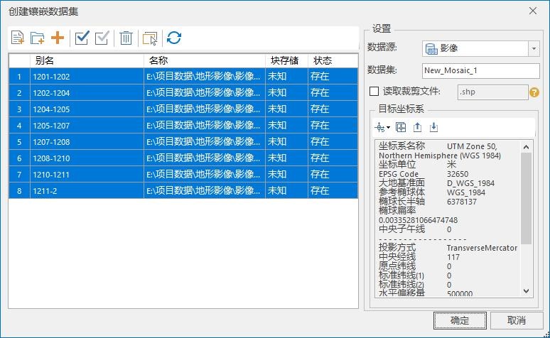
- ③The specific operation of the mosaic dataset refers to the following link:https://blog.csdn.net/supermapsupport/article/details/74452385
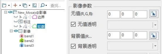
- ④Generate global subdivision map tiles: add the mosaic dataset to the map, set the boundary, label, and contour layers to be invisible (otherwise the generated tiles will be included), set the background of the image layer to be transparent, Invalid value color transparent two properties.
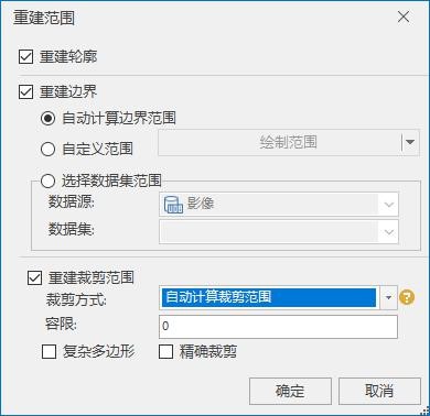
If there is an invalid color value in the valid area, use another way to remove the invalid area, right click on the mosaic dataset, and select "Rebuild Range"; you can import the boundary of the valid area, or automatically calculate the effective range of the mosaic dataset.
For the map of the projected coordinate system, set the dynamic projection conversion and convert it to the corresponding geographic coordinate system (not all of them are converted to 4326, and the projected coordinate system of China2000 needs to be dynamically converted to the geographic coordinate system of China2000)
Save the map, and generate global map tiles with multiple tasks (multiple machines can be parallelized).
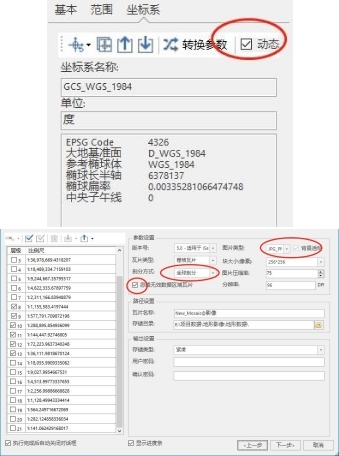
Level selection: 01.m image resolution generates the highest level of 21 layers; 0.2m has 20 layers; 0.5m has 19 layers; 1m has 18 layers; 2m has 17 layers; 4m has 16 layers, and so on.
If it is only loaded in the 3D scene in the end, then only the highest layer tiles can be generated, and the pyramid layer will be automatically generated by converting to sci3d in the fifth step.
- ⑤Convert the generated map cache to sci3d image cache tool address: linkhttps://eyun.baidu.com/s/3dzbgVO密码:8SsM
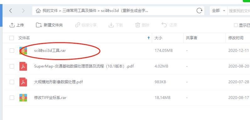
webp has a higher compression ratio, it is recommended to check it. If there are vector data (points, lines, areas) in the map, you must check the "Vector Data" option, otherwise you don't need to check it.
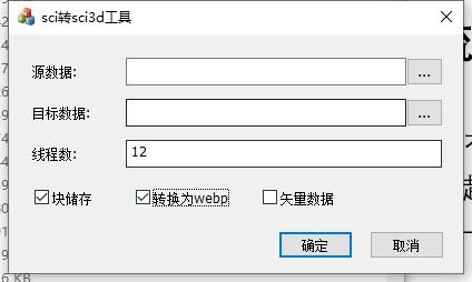
In order to improve the download and loading efficiency of terrain images, 10.1 and later versions provide a block storage method for terrain image cache, which can be directly upgraded to block storage.
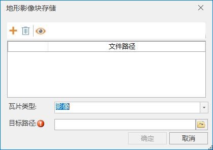
In version 10.1 of iDesktop, it is also possible to upgrade non-block storage terrain and image tiles to block storage, and also supports saving terrain image tiles to MongoDB, which is convenient for organization and management.
"3D Data" tab, "Terrain Image Block Storage" under "Cache Tools"
In the "3D Data" tab, "Save to MongoDB"
If you pursue higher loading performance and experience, it is recommended to generate block storage tiles. The highest performance is block large file storage, followed by MongoDB.
Images of the same resolution are best generated in one map, and images of different resolutions are generated in different maps.
- ⑥Front-end batch request loading (version 10.01 non-block storage images, the front-end supports batch download)
If it is a version before 10.1, just use the tool to convert to sci3d (do not check block storage, versions before 10.1 do not support).
You can also experience the loading effect of block storage in version 10.1 by enabling batch requests on the front end. The data in block storage does not need to add the line of code packingRequest:1.
var provider_img = new SuperMap3D.SuperMapImageryProvider({
                   url : 'url',
                   packingRequest:1//bulk request
                 });