

URI
<maps_uri>/{id}[.<format>]
支持的方法
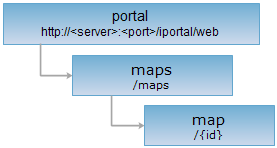
父资源
子资源
mapStatus、mapShareSetting、mapVisitCount、mapAttributes、mapDayVisits、WebMap、mapThumbnail
介绍
地图资源。支持查看、修改和删除操作。
支持的方法:
- GET:获取指定的地图信息。
- PUT:修改指定的地图信息。只有授权是可编辑的地图,才能进行修改。
- DELETE:删除指定的地图信息。
- HEAD:检查 map 资源是否存在,或权限是否可以访问 map 资源。
支持的表述格式:RJSON、JSON、HTML、XML。
资源层次
HTTP 请求方法
对如下 URI 执行 HTTP 请求,以 rjson 输出格式为例加以说明,其中,supermapiportal 是服务器名。
http://supermapiportal:8190/iportal/web/maps/{id}.rjson
GET 请求
获取指定的地图信息。
响应结构
对 map 资源执行 GET 请求,返回的资源表述结构如下:
| 名称 | 类型 | 含义 |
| authorizeSetting | List<IportalAuthorizeEntity> | 授权信息。 |
| center | Point2D | 地图的中心点。 |
| checkStatus | CheckStatus | 根据审核状态过滤。 |
| checkTime | Long | 审核时间。 |
| checkUser | String | 审核人名称。 |
| checkUserNick | String | 审核人昵称。 |
| controls | List<String> | 地图显示控件集合。 |
| createTime | Long | 地图的创建时间。 |
| description | String | 地图描述信息。 |
| epsgCode | Integer | 投影坐标系对应的 EPSG 代码。 |
| extent | Rectangle2D | 地图的范围。 |
| id | Integer | 地图的标识。 |
| isDefaultBottomMap | Boolean | 是否是默认底图,该参数已过期。 |
| layers | List<Layer> | 地图的图层列表,该参数已过期。 |
| level | Integer | 地图的缩放级别。 |
| nickname | String | 用户的昵称。 |
| resolution | double | 地图的地面分辨率。 |
| searchSetting | String | 地图保存的搜索设置。 |
| sourceType | SourceType | 地图的来源类型。 |
| status | ViewerMapStatus | 地图状态 save、publish。该参数已过期,即 SuperMap iPortal 8C 版或更高版本将不再沿用此参数。 |
| tags | List<String> | 地图标签。 |
| thumbnail | String | 地图的缩略图路径。 |
| title | String | 地图名称。 |
|
units |
String | 地图的单位。默认是'degrees'。可选值为'degrees'(或者'dd')、‘m’、'ft'、'km'、'mi'、'inches'。 |
|
updateTime |
Long | 地图的更新时间。 |
|
userName |
String | 用户的标识。 |
|
verifyReason |
String | 审核意见。 |
|
visitCount |
Integer | 地图的访问次数。 |
|
projectInfo |
String | 工程信息:记录除门户信息、WebMap 之外的信息。 |
响应示例
对 map 资源:http://localhost:8190/iportal/web/maps/1108937140.rjson 执行 GET 请求,返回的 rjson 格式的表述如下:
{
"extent": {
"top": 20037508.3427892,
"left": -20037508.3427892,
"bottom": -20037508.3427892,
"leftBottom": {
"x": -20037508.3427892,
"y": -20037508.3427892
},
"right": 20037508.3427892,
"rightTop": {
"x": 20037508.3427892,
"y": 20037508.3427892
}
},
"controls": null,
"extentString": "{\"top\":2.00375083427892E7,\"left\":-2.00375083427892E7,\"bottom\":-2.00375083427892E7,\"leftBottom\":{\"x\":-2.00375083427892E7,\"y\":-2.00375083427892E7},\"right\":2.00375083427892E7,\"rightTop\":{\"x\":2.00375083427892E7,\"y\":2.00375083427892E7}}",
"description": "",
"verifyReason": null,
"units": null,
"title": "全国省会点",
"resolution": 0,
"checkStatus": "SUCCESSFUL",
"projectInfo": "{}",
"visitCount": 3,
"centerString": "{\"x\":1.2701816909064028E7,\"y\":4016550.751464985}",
"epsgCode": 3857,
"nickname": "admin",
"layers": [
{
"wmtsOption": null,
"styleString": "null",
"title": "中国暗色地图",
"type": null,
"subLayersString": "null",
"WMTSOptionString": "null",
"features": null,
"boundsString": "null",
"prjCoordSys": null,
"id": null,
"cartoCSS": null,
"datasourceName": null,
"prjCoordSysString": "null",
"identifier": null,
"layerType": null,
"featuresString": "null",
"WMTSOption": null,
"themeSettings": "{\"layerType\":\"TILE\",\"sourceType\":\"SUPERMAP_REST\",\"epsgCode\":\"EPSG:3857\",\"name\":\"中国暗色地图\",\"url\":\"https://maptiles.supermapol.com/iserver/services/map_China/rest/maps/China_Dark\",\"zIndex\":0}",
"isVisible": true,
"subLayers": null,
"url": "https://maptiles.supermapol.com/iserver/services/map_China/rest/maps/China_Dark",
"zindex": null,
"scalesString": "null",
"scales": null,
"name": "dv_v5_rest",
"bounds": null,
"mapId": null,
"style": null,
"markersString": "null",
"opacity": 1,
"markers": null
},
{
"wmtsOption": null,
"styleString": "null",
"title": "全国省会点",
"type": null,
"subLayersString": "null",
"WMTSOptionString": "null",
"features": null,
"boundsString": "null",
"prjCoordSys": null,
"id": null,
"cartoCSS": null,
"datasourceName": null,
"prjCoordSysString": "null",
"identifier": null,
"layerType": null,
"featuresString": "null",
"WMTSOption": null,
"themeSettings": "{\"layerType\":\"VECTOR\",\"visible\":true,\"xField\":\"X\",\"styleCache\":{\"VECTOR\":{\"fillColor\":\"#EE4D5A\",\"strokeWidth\":1,\"fillOpacity\":0.9,\"radius\":8,\"strokeColor\":\"#ffffff\",\"strokeOpacity\":1}},\"yField\":\"Y\",\"name\":\"全国省会点\",\"featureType\":\"POINT\",\"fileCode\":\"EPSG:4326\",\"serverId\":\"433046314\",\"zIndex\":1}",
"isVisible": true,
"subLayers": null,
"url": null,
"zindex": null,
"scalesString": "null",
"scales": null,
"name": "dv_v5_vector",
"bounds": null,
"mapId": null,
"style": null,
"markersString": "null",
"opacity": 1,
"markers": null
}
],
"id": 1108937140,
"searchSetting": null,
"thumbnail": "http://127.0.0.1:8190/iportal/services/../resources/thumbnail/map/map1108937140.png",
"level": 5,
"center": {
"x": 12701816.909064,
"y": 4016550.75146498
},
"authorizeSetting": [
{
"permissionType": "DELETE",
"aliasName": "admin",
"entityRoles": [
"ADMIN",
"SYSTEM"
],
"entityType": "USER",
"entityName": "admin",
"entityId": null
}
],
"updateTime": 1607652533180,
"userName": "admin",
"tags": [
"用户地图"
],
"checkUser": null,
"checkUserNick": null,
"checkTime": null,
"sourceType": "MAPVIEWER",
"createTime": 1607652533180,
"controlsString": "",
"isDefaultBottomMap": false,
"status": null
}
PUT 请求
修改指定的地图信息。只有授权是可编辑的地图,才能修改,即"permissionType": "READWRITE"。
请求参数
发送请求时,需要在请求体中传递如下参数:
| 名称 | 类型 | 含义 |
|
units |
String | 【必填参数】地图的单位。默认是'degrees'。可选值为'degrees'(或者'dd')、‘m’、'ft'、'km'、'mi'、'inches'。 |
| level | Integer | 【必填参数】地图的缩放级别。 |
| center | Point2D | 【必填参数】地图的中心点。 |
| controls | List<String> | 【必填参数】地图显示控件集合。 |
| description | String | 【必填参数】地图描述信息。 |
| epsgCode | Integer | 【必填参数】投影坐标系对应的 EPSG 代码。 |
| extent | Rectangle2D | 【必填参数】地图的范围。 |
| status | ViewerMapStatus | 地图状态 save、publish。该参数已过期,即 SuperMap iPortal 8C 版或更高版本将不再沿用此参数。 |
| tags | List<String> | 【必填参数】地图标签。 |
| layers | List<Layer> | 【必填参数】地图的图层列表。 |
| title | String | 【可选参数】地图名称。 |
| thumbnail | String | 【可选参数】地图的缩略图路径。 |
| sourceType | SourceType | 【必填参数】地图的来源类型。 |
| authorizeSetting | List<IportalAuthorizeEntity> | 【可选参数】授权信息。 |
响应结构
返回的资源表述结构如下:
| 字段 | 类型 | 说明 |
| succeed | boolean | 修改地图是否成功。 |
| error | Httperror | 出错信息,如果修改地图成功,则没有本字段。 |
响应示例
修改地图名称,对 map 资源:http://localhost:8190/iportal/web/maps/4.rjson 执行 PUT 请求,发送请求体如下:
{
"units": null,
"level": 0,
"center": {
"id": "SuperMap.Geometry.Point_62",
"x": 0,
"y": -2.2351741790771E-08
},
"controls": [],
"description": "暂无描述信息",
"epsgCode": 3857,
"extent": {
"left": -80306576.405087,
"bottom": -51659201.196255,
"right": 80306576.405087,
"top": 51659201.196255
},
"thumbnail": "http://192.168.120.40:8090/iserver/services/map-china400/rest/maps/China/entireImage.png",
"scale": 1.69016357160266E-09,
"authorizeSetting": [
{
"permissionType": "DELETE",
"aliasName": "admin",
"entityType": "USER",
"entityName": "admin",
"entityId": null
},
{
"permissionType": "READ",
"aliasName": "GUEST",
"entityType": "USER",
"entityName": "GUEST",
"entityId": null
}
],
"status": null,
"title": "China_test",
"tags": [
"系统地图"
],
"userName": "admin",
"sourceType": "SUPERMAP_REST",
"visitCount": 4,
"resolution": 156543.033928045,
"id": null,
"layers": [
{
"title": "China",
"url": "http://192.168.120.40:8090/iserver/services/map-china400/rest/maps/China",
"opacity": 1,
"zindex": 0,
"type": "SUPERMAP_REST",
"layerType": "BASE_LAYER",
"name": null,
"bounds": {
"left": -20037508.342789,
"bottom": -20037508.342789,
"right": 20037508.342789,
"top": 20037508.342789
}
}
]
}
则返回的 rjson 格式响应结果如下:
{ "succeed": true}
DELETE 请求
删除指定 id 的地图。
响应结构
返回的资源表述结构如下:
| 字段 | 类型 | 说明 |
| succeed | boolean | 删除地图是否成功。 |
| error | Httperror | 出错信息,如果删除地图成功,则没有本字段。 |
响应示例
对 map 资源:http://localhost:8190/iportal/web/maps/8.rjson 执行 DELETE 请求,返回的 rjson 格式响应结果如下:
{ "succeed": true}
HEAD 请求
返回跟 GET 请求一样的 HTTP 响应头,但是没有响应实体。可以在不必传输整个响应内容的情况下,获取包含在响应消息头中的元数据信息。元数据信息包括媒体类型,字符编码,压缩编码,实体内容长度等。
HEAD 请求可以用来判断 map 资源是否存在,或者客户端是否有权限访问 map 资源。通过对加.<format>的 URI 执行 HEAD 请求,还可以快速判断 map 资源是否支持<format>格式的表述。
请参见
- maps、mapStatus、mapShareSetting、mapVisitCount、mapAttributes、mapDayVisits、WebMap
- 客户端构建 REST 请求
- 状态码列表及说明
- SuperMap iServer REST API 表述格式介绍
- 资源层次结构