ZXY Standard Tile |
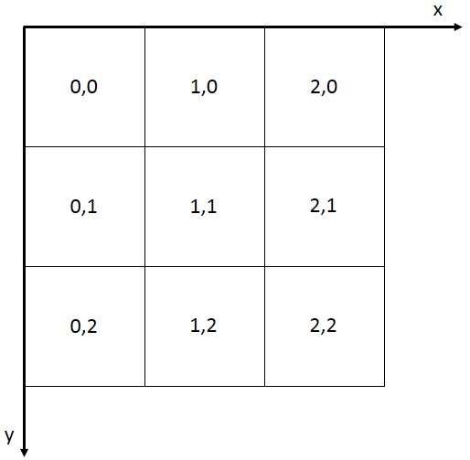
SuperMap iServer and iEdge support to read map tiles of the ZXY standard, in order to use OpenStreetMap and other Internet tile map services. The tiling rules for ZXY tiles are as follows: divide the map in full extent from the top left corner, from top to bottom and from right to left, into tiles of 256 * 256 pixels each. The upper left corner is numbered as line 0, column 0, and the number increases as it goes to the down and right directions. As shown below:
The map tiles of the ZXY specification only support the Web Mercator coordinate system (i.e. the PCS_WGS_1984_WORLD_MERCATOR, EPSG Code:3857). As shown in Table 1, the initialization display level 0 of this scale definition contains a 256 * 256 slice covering the whole world, and the origin coordinates are defined as (-20037508.34, 20037508.34), which is the upper left corner of the globe.
Table 1 Parameter List for Each Zoom Level of zxyTileImage Resource
| Display Level | Map Width and Height (pixels) | Number of Tiles | Ground Resolution (m/pixel) | Map Scale (96 dpi) |
| 0 | 256 | 1 | 156543.033928 | 1:591658710.909131 |
| 1 | 512 | 4 | 78271.516964 | 1:295829355.454566 |
| 2 | 1024 | 16 | 39135.758482 | 1:147914677.727283 |
| 3 | 2048 | 64 | 19567.879241 | 1:73957338.863641 |
| 4 | 4096 | 256 | 9783.939621 | 1:36978669.431821 |
| 5 | 8192 | 1024 | 4891.969810 | 1:18489334.715910 |
| 6 | 16384 | 4096 | 2445.984905 | 1:9244667.357955 |
| 7 | 32768 | 16384 | 1222.992453 | 1:4622333.678978 |
| 8 | 65536 | 65536 | 611.496226 | 1:2311166.839489 |
| 9 | 131072 | 262144 | 305.748113 | 1:1155583.419744 |
| 10 | 262144 | 1048576 | 152.874057 | 1:577791.709872 |
| 11 | 524288 | 4194304 | 76.437028 | 1:288895.854936 |
| 12 | 1048576 | 16777216 | 38.218514 | 1:144447.927468 |
| 13 | 2097152 | 67108864 | 19.109257 | 1:72223.963734 |
| 14 | 4194304 | 268435456 | 9.554629 | 1:36111.981867 |
| 15 | 8388608 | 1073741824 | 4.777314 | 1:18055.990934 |
| 16 | 16777216 | 4294967296 | 2.388657 | 1:9027.995467 |
| 17 | 33554432 | 17179869184 | 1.194329 | 1:4513.997733 |
| 18 | 67108864 | 68719476736 | 0.597164 | 1:2256.998867 |
| 19 | 134217728 | 274877906944 | 0.298582 | 1:1128.499433 |
| 20 | 268435456 | 1099511627776 | 0.149291 | 1:564.249717 |
| 21 | 536870912 | 4398046511104 | 0.074646 | 1:282.124858 |
| 22 | 1073741824 | 17592186044416 | 0.037323 | 1:141.062429 |
| 23 | 2147483648 | 70368744177664 | 0.0186615 | 1:70.5312145 |
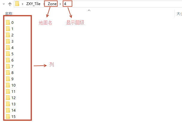
The storage structure of ZXY tiles is shown in the following figure, where the first level folder under the map name is the display hierarchy, and the next level folder is the tile column. The images in the column folder are rows.