GIS System |
From a system perspective, GIS is a computer system that collects, stores, manages, queries, analyzes, and expresses geographic information for display and application. It is also a universal technology for analyzing and processing massive geographic data.
GIS regards the whole earth space as the object, records and stores the ground objects and symbols in the real world as Data, integrates the data into Information, extracts useful Knowledge from the information through spatial analysis, geographic data processing and other professional methods, and finally through the analysis of auxiliary decision-making, the whole earth space can be used as a whole. The conclusion is analyzed from the knowledge extracted from GIS, that is, Wisdom.
Cloud GIS applies the characteristics of cloud computing technology to GIS system to support the collection, storage, display, modeling, processing and analysis of geographic information, bringing a more friterminally, more efficient and lower cost mode of using geographic information resources.
Due to the particularity of GIS data and services, when using GIS services, in addition to focusing on GIS cloud services, we often need to focus on specific GIS clients in different scenarios. If the party that provides GIS cloud services is called "GIS cloud", the party that uses services can be called "GIS terminal", which are the two main bodies of cloud integrated GIS. But only these two main bodies are not enough, because the interaction between GIS side and GIS cloud has a certain complexity, so we should also pay attention to the interaction between GIS cloud and GIS side-integrated GIS technology. Therefore, the cloud integrated GIS technology system includes three components: GIS cloud technology, GIS terminal technology and integrated GIS technology. The three technologies respectively realize the three parts of the cloud integrated GIS system: intensive GIS cloud platform, diversified GIS terminal and integrated GIS system.
SuperMap GIS based on cloud integrated GIS technology system provides powerful cloud GIS portal software platform, server GIS software platform and GIS edge software platform, as well as rich mobile terminal and Web terminal, PC terminal products and development packages, to help customers build strong cloud rich terminal, interconnection and sharing, safe and stable, flexible and reliable GIS system.
SuperMap GIS based on cloud integrated GIS technology system provides powerful cloud GIS portal software platform, server GIS software platform and GIS edge software platform, as well as rich mobile terminal and Web terminal, PC terminal products and development kits. SuperMap GIS product system helps to build a cloud integrated GIS application system with strong cloud, rich terminal, interconnection, mutual sharing, security, stability, flexibility and reliability through the complete GIS software from cloud to terminal.
Specifically, through the GIS cloud manager iManager, the cloud GIS portal software platform iPortal, the server GIS software platform IServer, as well as the GIS edge software platform iEdge, quickly build a powerful cloud GIS platform. Through GIS across mobile terminal, Web terminal, PC terminal and other types of terminals Software iMobile, iClient, iDesktop and iObjects help to build client applications across multiple platforms and connect cloud GIS service platforms and supermap cloud service on diverse devices. Multi-terminal applications can use the cloud GIS data and services in the GIS platform can display geographic information in multiple ways, and can also collect, produce and upload data to the cloud platform for the cloud platform.
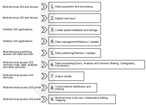
Taking the process of GIS data processing as an example, in the application of cloud integration, each software from cloud to terminal participates in the process of GIS data collection, processing, storage, analysis, release and distribution, and the software of each platform plays its own advantages and performs its own duties to form a complete GIS system.
As can be seen from the figure below, the terminal applications of various devices can collect and process data, and are no longer limited to desktop applications. In addition, the process of data use does not terminal with the output of processing and analysis results, and the output results can be distributed and shared among multiple users and devices, and can be further used and edited by other users. The whole data flow is no longer a static process from input to output, but a dynamic process that may be updated and shared by other users at any time. Therefore, the current In the application of GIS, the mobile application of multi-device and close to users broadens the data sources for GIS, and also broadens the application scenarios of GIS data, and the whole data flow is more open.