 Introduction
Combine two or more raster datasets into one dataset based on its geographic coordinate system.
e.g.:
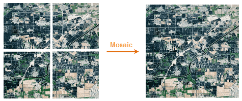
Figure 1 shows the raster datasets that have no common parts. Figure 2 shows you how to mosaic the taster datasets that have overlaid parts.
 Basic Steps
- Click Data Processing, Raster Mosaic.
- The Mosaic dialog box pops up.
- Add raster datasets.
- Raster dataset type: Grid and Image. But the two types cannot be mixed.
If you want to change the type, you must delete the added dataset first.
 Instruction for Toolbar Button
-
 Click Add, and select raster datasets.
 -
 Click Remove to remove datasets.
 -
 Click Select All to select all datasets.
 -
 Click Select Inverse.
 -
 Forward the dataset.
 -
 Backward the dataset.
 -
 Top the dataset.
 -
 Bottom the dataset.
 - Parameter settings.
Parameter Settings
 Raster parameter settings
-
Overlay Area Values: Gets cell values, such as elevation, rainfall, etc. There are five approaches:
- Same as First: The cell values for the first raster dataset.
- Same as last: The cell values for the last raster dataset.
- Max of All Datasets: The max cell value of the raster dataset.
- Min of All Datasets: The min cell value of the raster dataset.
- Mean of All Datasets: The mean cell value of the raster dataset.
-
Format: Sets the pixel type for the result dataset.
- Same as First: The pixel format for the first raster dataset.
- Same as Last: The pixel format for the last raster dataset.
- Highest Precision: The pixel format of the raster dataset that has the highest precision.
- Lowest Precision: The pixel format of the raster dataset that has the lowest precision.
- Most Frequent: The pixel format of the raster datasets that have the most frequent.
- Pixel Format: There are bit1, bit4, bit8, bit16, integer, long integer, float, double. See Pixel types of raster dataset.
- NoValue Data: Set a value if the dataset is null.
- Tolerance: Set the tolerance of the no value data.
 Image parameter settings
-
Overlay Area Values: Gets cell values, including color value or color index. There are two approaches:
- Same as First: The cell values for the first raster dataset.
- Same as Last: The cell values for the last raster dataset.
- Max of All Datasets: Get the max values of R, G, B
- Min of All Datasets: Get the min values of R, G, B
- Mean of All Datasets: Get the mean values of R, G, B
-
Format: Sets the pixel type for the result dataset. Notes: The pixel formats do not support the single and double float of image dataset mosaic.
- Same as First: The pixel format for the first image dataset.
- Same as Last: The pixel format for the last image dataset.
- Highest Precision: The pixel format of the image dataset that has the highest precision.
- Lowest Precision: The pixel format of the image dataset that has the highest precision.
- Most Frequent: The pixel format of the image datasets that have the most frequent.
- Pixel Format: There are Monochrome, 16-color, 256-color, true color, enhanced true color. See Pixel types of image dataset.
- Background: If a cell is the same to this color, it will be treated as background color. In this case, the color will not join to operation.
- Tolerance: Set the tolerance of the background color.
Result Dataset
- Datasource: By default the datasource is the dataset to be mosaicked.
- Dataset: The name of the result dataset.
- Encoding: SGL, DCT, LZW, PNG, Compound. Default is None. See Dataset Compact Encoding.
Encoding for raster dataset:
| Original Encoding | Usable Encoding | |||||||
|---|---|---|---|---|---|---|---|---|
| 1 Bit | 4 Bit | Single-byte | Double-byte | Integer | Long integer | Float | Double | |
| NONE | LZW | LZW | LZW, SGL | LZW, SGL | LZW, SGL | NONE | LZW, SGL | LZW, SGL |
| SGL | LZW | LZW | SGL | SGL | SGL | NONE | SGL | SGL |
| LZW | LZW | LZW | LZW | LZW | LZW | NONE | LZW | LZW |
Encoding for image dataset:
| Original Encoding | Usable Encoding | |||||||
|---|---|---|---|---|---|---|---|---|
| Monochrome | 16-color | 256-color | Color | True color | Enhanced color | |||
| NONE | LZW, PNG | LZW, PNG | LZW, DCT, PNG, compound | LZW, DCT, compound | LZW, DCT, PNG, compound | LZW, DCT, PNG, compound | ||
| LZW | LZW | LZW | LZW | LZW | LZW | LZW | ||
| DCT | LZW | LZW | DCT | DCT | DCT | DCT | ||
| PNG | PNG | PNG | PNG | DCT | PNG | PNG | ||
| Compound | LZW | LZW | Compound | Compound | Compound | Compound |
- Create Image Pyramid: To improve the view speed.
- Parameter settings.
Set the extent of the result dataset.
- Click OK to perform.
 Notes
Notes
The pixel formats do not support single and double floats of image dataset mosaic.

