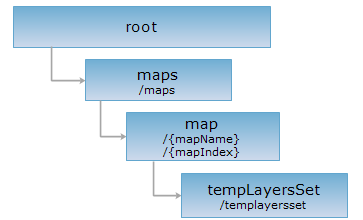
<map_uri>/templayersset[.<format>]
临时图层集集合资源,做为 map 资源的一个子资源,通过对 tempLayersSet 执行 POST 操作,可以创建临时图层集,即 tempLayers 资源,一个 tempLayers 资源对应一幅临时的地图。关于创建的临时图层集在服务器端的存活时间,请参考:临时资源的生命周期。
支持的方法:
支持的表述格式:RJSON、JSON、HTML、XML、JSONP、FASTJSON。

对如下 URI 执行 HTTP 请求,以 RJSON 输出格式为例加以说明,其中,supermapiserver 是服务器名,“世界地图”是地图名({mapName})。
http://supermapiserver:8090/iserver/services/map-world/rest/maps/世界地图/tempLayersSet.rjson
获取地图中所有的临时图层集。
| 名称 | 类型 | 含义 |
| _cache | boolean | 【可选参数】
是否使用缓存,默认为 true。如果为 false,则关闭所有缓存。 |
对 tempLayersSet 资源执行 GET 请求,返回“世界地图”包含的临时图层集的信息,返回资源表述的是一个临时图层集描述数组,数组中的元素包含一个临时图层集的信息,单个元素的结构如下:
| 字段 | 类型 | 说明 |
| name | String | 临时图层集的名称。 |
| path | String | 临时图层集资源的访问路径。 |
| resourceConfigID | String | 资源配置项 ID。 |
| resourceType | String | 资源类型。 |
| supportedMediaTypes | String[] | 支持的表述的媒体类型。 |
对 tempLayersSet 资源执行 GET 请求,返回 rjson 格式的资源描述如下:
[{
"name": "1",
"path": "http://supermapiserver:8090/iserver/services/map-world/rest/maps/世界地图/tempLayersSet/1",
"resourceConfigID": "tempLayers",
"resourceType": "StaticResource",
"supportedMediaTypes": [
"application/xml",
"text/xml",
"application/json",
"application/rjson",
"text/html",
"application/jsonp",
"application/x-java-serialized-object"
]
}]
为地图创建临时图层集资源。
通过 POST 请求为地图创建一个临时图层集,URI 中可以包含如下参数:
| 名称 | 类型 | 含义 |
| returnContent | boolean | 表示立即返回新创建资源的表述还是返回新资源的 URI。如果为 true,则直接返回新创建资源,即临时图层集的表述。为 false,则返回的是临时图层集资源的 URI。默认为 false。 |
请求体参数:
请求体中需要包含一个临时图层集的描述,临时图层集中的元素可以是 UGCMapLayer、WMSLayer 、 WFSLayer 或 GeotrellisImageLayer 类型的,参数结构跟 layers 资源的表述结构一致。可以参见 layers 资源 GET 请求响应的结构。
如果请求体中的参数合法,SuperMap iServer 服务器会根据这些描述,在“世界地图”里创建一个临时图层集合,即 tempLayers 资源。当请求体参数为空时,则返回整个“世界地图”资源。
注意:请求体数组中有一个元素,标识了临时图层的地图状态,该元素一般是 UGCMapLayer。
对 tempLayersSet 资源执行 POST 请求,返回的操作结果表述的结构如下(表述在响应消息的实体主体里):
| 字段 | 类型 | 说明 |
| succeed | boolean | 创建临时图层集是否成功。如果不成功会有错误信息。 |
| newResourceID | String | 查询结果资源的 ID。 |
| newResourceLocation | String | 创建的临时图层集的 URI,标识一个 tempLayers 资源。 |
| error | HttpError | 出错信息,如果创建成功,则没有本字段。 |
| postResultType | postResultType | POST 请求结果的类型。说明 POST 请求对目标资源的影响,即处理结果是什么样的。 |
对 tempLayersSet 资源:http://supermapiserver:8090/iserver/services/map-world/rest/maps/世界地图/tempLayersSet.rjson,执行 POST 请求,消息体中包含一个矢量图层和一个标签专题图图层,如下:
[{
"name": "世界地图",
"type": "UGC",
"subLayers": {
"layers": [
{
"type": "UGC",
"caption": "大洋名称",
"ugcLayerType": "THEME",
"visible": true,
"theme": {
"labelExpression": "OceanLabelP_C.ChineseName",
"type": "LABEL",
"uniformStyle":{
"foreColor":{"red": 128,"blue": 0,"green": 0}
}
},
"datasetInfo": {
"name": "OceanLabelP_C",
"dataSourceName": "World",
"type": "POINT"
}
},
{
"type": "UGC",
"caption": "国家边界",
"ugcLayerType": "VECTOR",
"visible": true,
"datasetInfo": {
"name": "Countries",
"dataSourceName": "World",
"type": "LINE"
},
"style": {
"fillBackOpaque": true,
"lineWidth": 0.1,
"fillBackColor": { "red": 255, "blue": 255, "green": 255},
"fillForeColor": {"red": 242, "blue": 233, "green": 239},
"lineColor": {"red": 128, "blue": 128, "green": 128},
"fillOpaqueRate": 100,
"fillGradientMode": "NONE",
"fillSymbolID": 0,
"fillGradientAngle": 0,
"lineSymbolID": 0
}
}
]
}
}]
则返回的操作结果表述的结构如下(表述在响应消息的实体主体里):
{
"succeed": true,
"newResourceID": "p590w5yp_1",
"newResourceLocation": "http://supermapiserver:8090/iserver/services/map-world/rest/maps/世界地图/tempLayersSet/p590w5yp_1.rjson"
}
当临时图层集中的元素是 GeotrellisImageLayer 类型,请参考:GeotrellisImageLayer,对 tempLayersSet 资源:http://supermapiserver:8090/iserver/services/map-Geotrellis/rest/maps/GeotrellisLayer/tempLayersSet/tempLayersSet.rjson,执行 POST 请求,如下:
[{
"visible": true,
"maxScale": 1.3845819978568952E-5,
"colorSpaceType": "RGB",
"displayBandIndexes": [
0,
1,
2
],
"caption": "multiple1",
"description": null,
"subLayers": {},
"type": "GEOTRELLISIMAGELAYER",
"displayMode": "COMBINE",
"queryable": false,
"alpha": 255,
"name": "multiple1",
"bounds": {
"top": 894022.5039911582,
"left": 1.2188914223175082E7,
"bottom": 780583.7483448264,
"leftBottom": {
"x": 1.2188914223175082E7,
"y": 780583.7483448264
},
"right": 1.2357058983170727E7,
"rightTop": {
"x": 1.2357058983170727E7,
"y": 894022.5039911582
}
},
"minScale": 1.6901635716026553E-9
}]
其中colorSpaceType为色彩空间枚举,请参考:colorSpaceType;displayBandIndexes为显示的波段索引,依照颜色模式顺序,如RGB为[0,1,2];alpha为图层透明度。
则返回的操作结果表述的结构如下(表述在响应消息的实体主体里):
{
"succeed": true,
"postResultType":"CreateChild",
"newResourceID":"aa2b8f9271ec4e80af93025c6c680885_b15b7b605c3d41e89ab8123b54bd818e",
"newResourceLocation": "http://localhost:8090/iserver/services/map-Geotrellis/rest/maps/GeotrellisLayer/tempLayersSet/aa2b8f9271ec4e80af93025c6c680885_b15b7b605c3d41e89ab8123b54bd818e.rjson"
}
返回跟 GET 请求一样的 HTTP 响应头,但是没有响应实体。可以在不必传输整个响应内容的情况下,获取包含在响应消息头中的元数据信息。元数据信息包括媒体类型,字符编码,压缩编码,实体内容长度等。
HEAD 请求可以用来判断 tempLayersSet 资源是否存在,或者客户端是否有权限访问 tempLayersSet 资源。通过对加.<format>的 URI 执行 HEAD 请求,还可以快速判断 tempLayersSet 资源是否支持<format>格式的表述。